
26 August 2025
For being a self-proclaimed lover of cartography, I am not the best map reader. Rather, I continually fail to appreciate scale. Too many times I have tricked myself into hikes to reach summits that “don’t look that far.” Oh look, there’s another just must along that ridge. I could do both of those in one day.
Yep. I sure can, but to the detriment of losing a whole day out in the woods (read as being absent from my family), and demolishing myself physically. I am not complaining whatsoever. I just either need to accept the fact that I am an over-doer, or try to ease back my intensity for planning hikes. I will probably go with the first one as it’s worked so far.
All of that to say Monday’s hike to Moors Mountain (W7M/CL-062) and a neighboring unnamed summit (W7M/CL-076) was a full day affair. I arrived at the Refrigerator Canyon trailhead (TH) early and was on the trail by 6:40 am, sunlight not quite touching the surrounding peaks. Anyone in the Helena area that has not checked out Refrigerator Canyon I highly recommend it. The narrow slot canyon is a short hike from the TH and provides a beautifully green, and cool, respite during the summer heat. The narrowest point has a little creek running through and generally a perpetual cool breeze squeezing down through it.
It felt almost chilly as I hiked up and beyond the narrows. Not long after as I gained elevation I felt a waft of warmth as an inversion of heat was settled up in the valley above. It was a truly peaceful morning. Just the birds and chipmunks going about their daily business. I could hear larger animals (probably elk) scampering off as I hurriedly hiked up the valley. I could hear them breaking off branches of downed trees as they sped away from me out of sight through the veil of trees.
An hour into the hike I was making good time and had reached the Willow Creek trail intersection above the Refrigerator Canyon drainage. From here I just had an idea of how to get up to Moors Mountain as there was not a designated trail. Time for some off-trail trailblazing, my favorite. At the next draw in the trail I found a route to head up steeply away from the trail, up and towards a ridge.
I packed extra light for once. I had my day pack and my LNR Precision MTR4B, CW only, HF radio. I felt amazingly light for a change and made great time as I zig-zagged my way up the steep incline. After passing through a level meadow I went back into a thick stand of fir trees. The ground was littered with elk pints and it was clear it was a favorite hang out spot with the local herd but there was none in sight. I took that opportunity to follow their well-worn paths further up the mountain. I love following game trails. Just the thought of how many elk and deer have passed before to make such trails makes me appreciate them all the more.
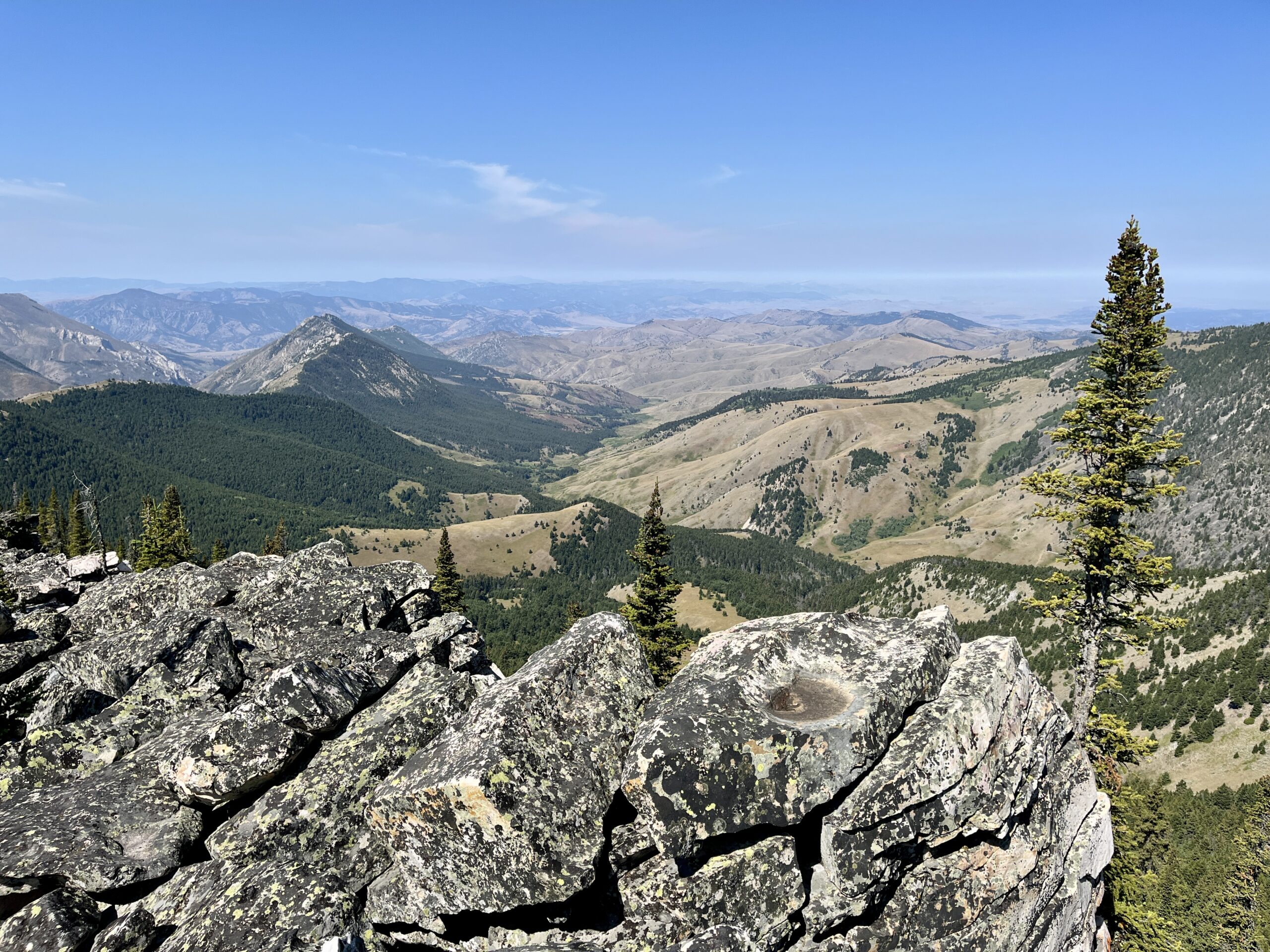
The last push to the summit of Moors Mountain along the south side maintained its steepness for entirely too long. Rounding the top of the nearly eight thousand foot peak gave way to a nice, lightly wooded summit with a nearly unobstructed view. The wind was nearly dead calm. The air was no longer crisp as the sun was quickly gaining height so I found a shaded spot behind a dwarfed fir. The hike to the summit was about five-and-a-half miles so it felt good to sit and take a break for a minute and eat some food and drink some water.
9:30 am, an hour before my scheduled arrival time, I set up my roll-up J-pole antenna to talk to the locals and set out my End Fed Half Wave (EFHW). First in the log, Bill, N7MSI, apparently with his finger on the trigger as he came right back to my call on 2 meters. A few more on 2 meters and it was on to HF.
It had been a while since I’d used the MTR4B. This small but mighty radio is one of my favorites to operate. This four-band rig works on 80-40-30-20 meters. The day prior I set up my EFHW in the back yard to confirm which bands it was resonant on. 40 and 20 meters were going to be my only options for that radio. Side note, I need to make a new linked dipole for my SOTA adventures as I had left several dipoles on Wake Island.
Twenty-three contacts made on Moors including two DX contacts with F4WBN, and JA0AWE, and were a nice addition to the log. After I finished up HF around 10:30 am, I scouted the map again for the best route over to the adjacent summit that was about two-and-a-half miles away; just outside of the Gates of the Mountain Wilderness Area. The alternative route to reach Moors or “7748” would be from the Beartooth Wildlife Management area via Holter Lake. From what I could see I would just follow the ridge down to the saddle and then back up the next summits’ ridge. That mostly worked out.
Coming down the last section of the Moors Mountain ridge on the northeast side down through a burn scar for a while then it was heavily wooded on the northern flank, and the southern side was mostly clear. Clear enough to show me how steep it was about to get. Once again I followed game trails to zig-zag down steeply through some pretty loose sections. Losing your footing in that section would have been highly detrimental so I took my time.
Heading up the next summit (“7748”) was a few hundred yards of grassy meadow, over a false summit, through another grassy meadow, and back up again into a expansive boulder field that covered the remaining distance to the summit. The north side of the ridge had a significant drop off where the tops of forty to fifty foot tall lodgepole pines were at eyeball height just a few feet away from the drop off. I steered clear of getting too close.
Once again ahead of schedule, I found Bill (N7MSI), or he found me, as soon as I put out my call on 2 meters. The rest of the activation was all 20 meters as no one picked me up on 40 meters. Twenty-four contacts logged from the second summit. With two activations completed it was time to make the long journey back. I chose not to retrace my steps back up and over Moors Mountain. My map app on my phone indicated there was a trail that traversed the saddle between the two mountains that would meet up with the Willow Creek trail that leads back to Refrigerator Canyon. It did, sort of.
I’m guessing it had been a long time since the trail had seen a maintenance crew. It was a mess for the next mile. Just a pile of pick-up-sticks littering the trail. It became a full body workout as I navigate up, over, and sometimes under all the dead fallen trees. Out into another meadow again I lost the trail as it vanished into the overgrown grasses. I roughly knew where the Willow Creek trail would transect my path down so I trekked on and on to the southwest and miraculously found the trail again.
This late in the season those meadows were quickly drying out that full of seed heads. I rarely hike in shorts but I did this day. My socks were proof as they were packed with pokie grass seeds. My shorts and legs were speckled in seeds that stuck on like velcro. At my first opportunity back on the trail I took off my shoes and socks and did my best to pick all of the seeds out. I was about eight miles into the day at this point and my legs were feeling surprisingly well. With the light pack and desire to get back at a reasonable hour I made the command decision to try and double time it back the last five miles.
Carefully running down the light decline of a well-worn but very narrow path I made good time. Just before the Refrigerator Canyon trail junction I took time to filter some much needed water from a spring along the trail. I chugged close to a liter of water before continuing down hill. Running the trail felt amazing and being hyper-focused on my footing helped the time fly by. I was back through the cool narrows and before I knew it I was at my vehicle. Immediately after unlocking it I found my sandals and bee-lined it to the creek. Stepping in the cool, ankle deep, water with my shoes on and splashing some on my face felt amazing. I used that opportunity to get most of the trail dust out of my shoes in a mountain creek style pre-rinse cycle.
My roundtrip adventure was about thirteen-and-a-half miles, with over five thousand feet of elevation gain. All in the name of SOTA points and due to my overindulgence in topography.
Thank you chasers! 73, Allen


